Pix4D adds AR compatibility with mobile app update
01 May 2024
Swiss-based Pix4D, a provider of drone and terrestrial mapping and photogrammetry solutions, announced the launch of PIX4Dcatch 2.0, an improved version of the company’s terrestrial scanning iOS mobile app.
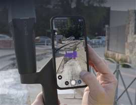
 A display of the iOS-based PIX4Dcatch 2.0 app from Swiss-based company Pix4D. (Image: Pix4D)
The upgraded application adds professional-grade augmented reality (AR) and compatibility with multiple real time kinematic (RTK) devices.
“PIX4Dcatch is an easy-to-use mobile 3D scanning and AR visualization tool. It is used by architecture, engineering, and construction (AEC) professionals worldwide, leveraging a combination of photogrammetry and LiDAR technology, and enhanced with RTK positioning for precision and accuracy,” said the company.
The new platform is integrated with three new RTK devices: the Emlid Reach RX, the Trimble DA2, and the Bad Elf Flex.
Pix4D said its technology is capable of scanning sites up to one centimetre of accuracy (in preferred conditions) with an average range between less than five centimetres and less than ten centimetres.
“The scans facilitate efficient documentation and visualization of existing site conditions and as-built measurements, which can be inspected in detail and exported to CAD/GIS for sharing and collaboration,” said Pix4D.
Construction applications for augmented reality
The addition of AR capabilities was a major highlight of the update, Pix4D stated.
“Using AR, plans can be overlaid on-site and visualized for rapid approval during project design, construction, and post-construction inspections. Annotations and field notes can be sent instantly from the office to the site where they can be viewed in context. Scans and 3D models of underground utilities can be visualized with AR even after closure, facilitating trench documentation and reducing maintenance costs,” said the firm.
STAY CONNECTED


Receive the information you need when you need it through our world-leading magazines, newsletters and daily briefings.
CONNECT WITH THE TEAM


